The Geospatial Data Abstraction Library (GDAL) is an open-source software library used to work with raster and vector geospatial data. There are a number of GDAL command-line interface (CLI) utilities that we can leverage to transform NISAR data.
Using GDAL to Transform NISAR Data
NISAR products are distributed in HDF5 format, and the files can be very large. Many users may want to transform the data by extracting just the datasets of interest from the HDF5 files and/or subsetting the data to a defined spatial extent.
We can use command-line utilities from the GDAL software library to transform these files. Leveraging GDAL’s ability to stream data from Earthdata Cloud directly allows us to download only the data we need in the desired format.
Installing GDAL
To use GDAL CLI commands, you must install GDAL locally. The process for installing GDAL differs based on the operating system installed on your computer, or the compute environment in which you wish to run the exported GDAL snippets.
Windows
The recommended method of installing GDAL on Windows is to install QGIS and utilize the OSGeo4W Shell, which provides GDAL.
MacOS
Install GDAL on MacOS with the Homebrew package manager. If you do not have Homebrew installed, first run the following command to install Homebrew:
/bin/bash -c "$(curl -fsSL https://raw.githubusercontent.com/Homebrew/install/HEAD/install.sh)"Then, install GDAL by running the following command:
brew install gdalLinux
Install GDAL using your distribution’s package manager. On Debian or Ubuntu systems run the following command:
sudo apt install gdal-binPreparing GDAL to Access EDC
In this guide, we will be streaming products directly from NASA’s Earthdata Cloud (EDC) without downloading them first. To do so, we must allow GDAL to authenticate to EDC by placing a .netrc file in the home directory of our compute environment containing our Earthdata Login credentials.
machine urs.earthdata.nasa.gov
    login <username>
password <password>machine urs.earthdata.nasa.gov
login <username>
password <password>Using a gdalrc File
Unix/Linux users can choose to generate a gdalrc file to simplify GDAL commands. This replaces the need to include --config flags for each command.
Create a file in ~/.gdal/gdalrc with the following content:
[configoptions]
CPL_VSIL_CURL_CHUNK_SIZE=2097152
CPL_VSIL_CURL_CACHE_SIZE=67108864
GDAL_CACHEMAX=64000000
GDAL_DISABLE_READDIR_ON_OPEN=TRUE
GDAL_HTTP_MERGE_CONSECUTIVE_RANGES=YES
GDAL_HTTP_MULTIPLEX=YES
GDAL_NUM_THREADS=ALL_CPUS
CPL_VSIL_CURL_CACHE_SIZE=1GB
GDAL_HTTP_NETRC=YES
GDAL_HTTP_COOKIEFILE=/tmp/gdal_cookies.txt
GDAL_HTTP_COOKIEJAR=/tmp/gdal_cookies.txt
If you have a gdalrc file staged, you can skip all the --config flags included in the sample commands on this page.
Transform NISAR HDF5 Products
Users can transform NISAR data by using the gdal_translate or gdalwarp utility to extract and/or spatially subset data, reproject the data, and change the file format. For the examples provided here, we will output the data as a GeoTIFF.
You will need the download link for a NISAR product to run these commands. Use the Copy URL links available in the search results for Vertex, or use one of the other available search methods to find a NISAR product URL. Users can also leverage Vertex’s GDAL Snippet Exporter tool to generate GDAL commands.

Figure 1:Click the Copy URL link to get the download URL for a NISAR product in Vertex.
Extract Datasets
Run the following gdalinfo command, using the download URL for a NISAR product, to view information about the product, including the datasets it contains:
gdalinfo "/vsicurl/https://<DOWNLOAD URL>" \
         --config GDAL_HTTP_NETRC=YES \
         --config GDAL_HTTP_COOKIEFILE=/tmp/gdal_cookies.txt \
         --config GDAL_HTTP_COOKIEJAR=/tmp/gdal_cookies.txt
gdalinfo "/vsicurl/https://<DOWNLOAD URL>" ^
--config GDAL_HTTP_NETRC=YES ^
--config GDAL_HTTP_COOKIEFILE=%TEMP%/gdal_cookies.txt ^
--config GDAL_HTTP_COOKIEJAR=%TEMP%/gdal_cookies.txtRefer to the Data Products section for more information about the datasets included in NISAR products.
Utilize the following gdal_translate command to extract a specific dataset from an HDF5 product as a GeoTIFF:
gdal_translate -of GTiff \
                "/vsicurl/https://<DOWNLOAD URL>":<VARIABLE PATH> <OUTPUT FILE>.tif \
                --config CPL_VSIL_CURL_CHUNK_SIZE 2097152 \
                --config CPL_VSIL_CURL_CACHE_SIZE 67108864 \
                --config GDAL_CACHEMAX 64000000 \
                --config GDAL_DISABLE_READDIR_ON_OPEN=TRUE \
                --config GDAL_HTTP_MERGE_CONSECUTIVE_RANGES=YES \
                --config GDAL_HTTP_MULTIPLEX=YES \
                --config GDAL_NUM_THREADS=ALL_CPUS \
                --config CPL_VSIL_CURL_CACHE_SIZE=1GB \
                --config GDAL_HTTP_NETRC=YES \
                --config GDAL_HTTP_COOKIEFILE=/tmp/gdal_cookies.txt \
                --config GDAL_HTTP_COOKIEJAR=/tmp/gdal_cookies.txt
gdal_translate -of GTiff ^
"/vsicurl/https://<DOWNLOAD URL>":<VARIABLE PATH> <OUTPUT FILE>.tif ^
--config CPL_VSIL_CURL_CHUNK_SIZE 2097152 ^
--config CPL_VSIL_CURL_CACHE_SIZE 67108864 ^
--config GDAL_CACHEMAX 64000000 ^
--config GDAL_DISABLE_READDIR_ON_OPEN=TRUE ^
--config GDAL_HTTP_MERGE_CONSECUTIVE_RANGES=YES ^
--config GDAL_HTTP_MULTIPLEX=YES ^
--config GDAL_NUM_THREADS=ALL_CPUS ^
--config CPL_VSIL_CURL_CACHE_SIZE=1GB ^
--config GDAL_HTTP_NETRC=YES ^
--config GDAL_HTTP_COOKIEFILE=%TEMP%/gdal_cookies.txt ^
--config GDAL_HTTP_COOKIEJAR=%TEMP%/gdal_cookies.txtThe gdalwarp command is also suitable for this, and can be used as a drop-in replacement. However, using gdal_translate for simple dataset extraction operations may provide up to a 30% improvement in performance.
Spatial Subsetting
GDAL has many utilities which allow for spatial subsetting. In this section we will demonstrate spatial subsetting through the use of the gdalwarp utility with WKT spatial extent strings.
The gdalwarp utility allows describing spatial extents using a type of string known as a Well Known Text (WKT) Polygon or MultiPolygon string (we will refer to them as WKT spatial extent strings), which are utilized widely across geospatial applications (see examples of WKT formulation).
An easy method for defining a WKT spatial extent string is to set an Area of Interest (AOI) in Vertex. Once you’ve drawn an AOI in Vertex, the Area of Interest WKT field displays the WKT spatial extent string, and hovering over the field exposes a copy icon that you can use to capture the WKT.
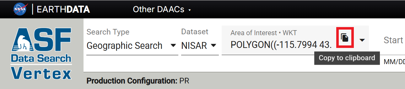
Figure 2:Click the Copy to clipboard icon in the Area of Interest WKT field in Vertex to copy the WKT spatial extent string to your system’s clipboard.
To perform spatial subsetting with gdalwarp, utilize the -cutline <WKT> flag alongside the -cutline_srs WGS84, -crop_to_cutline, and -dstalpha flags.
The command below demonstrates the use of these flags:
gdalwarp -of GTiff \
         "/vsicurl/https://<DOWNLOAD URL>":<VARIABLE PATH> <OUTPUT FILE>.tif \
         -cutline <WKT> \
         -cutline_srs WGS84 \
         -crop_to_cutline \
         -dstalpha \
         --config CPL_VSIL_CURL_CHUNK_SIZE 2097152 \
         --config CPL_VSIL_CURL_CACHE_SIZE 67108864 \
         --config GDAL_CACHEMAX 64000000 \
         --config GDAL_DISABLE_READDIR_ON_OPEN=TRUE \
         --config GDAL_HTTP_MERGE_CONSECUTIVE_RANGES=YES \
         --config GDAL_HTTP_MULTIPLEX=YES \
         --config GDAL_NUM_THREADS=ALL_CPUS \
         --config CPL_VSIL_CURL_CACHE_SIZE=1GB \
         --config GDAL_HTTP_NETRC=YES \
         --config GDAL_HTTP_COOKIEFILE=/tmp/gdal_cookies.txt \
         --config GDAL_HTTP_COOKIEJAR=/tmp/gdal_cookies.txt
gdalwarp -of GTiff ^
"/vsicurl/https://<DOWNLOAD URL>":<VARIABLE PATH> <OUTPUT FILE>.tif ^
-cutline <WKT> ^
-cutline_srs WGS84 ^
-crop_to_cutline ^
-dstalpha ^
--config CPL_VSIL_CURL_CHUNK_SIZE 2097152 ^
--config CPL_VSIL_CURL_CACHE_SIZE 67108864 ^
--config GDAL_CACHEMAX 64000000 ^
--config GDAL_DISABLE_READDIR_ON_OPEN=TRUE ^
--config GDAL_HTTP_MERGE_CONSECUTIVE_RANGES=YES ^
--config GDAL_HTTP_MULTIPLEX=YES ^
--config GDAL_NUM_THREADS=ALL_CPUS ^
--config CPL_VSIL_CURL_CACHE_SIZE=1GB ^
--config GDAL_HTTP_NETRC=YES ^
--config GDAL_HTTP_COOKIEFILE=%TEMP%/gdal_cookies.txt ^
--config GDAL_HTTP_COOKIEJAR=%TEMP%/gdal_cookies.txtReprojection
The gdalwarp utility can also be used to reproject datasets from the projection used for the source NISAR HDF5 product to a different spatial reference system.
In your gdalwarp command, set the -t_srs <SRS> flag, where <SRS> is the EPSG code for the desired output spatial reference system (such as EPSG:3857 for Web Mercator):
gdalwarp -of GTiff \
         "/vsicurl/https://<DOWNLOAD URL>":<VARIABLE PATH> <OUTPUT FILE>.tif \
         -t_srs <SRS> \
         -dstalpha \
         --config CPL_VSIL_CURL_CHUNK_SIZE 2097152 \
         --config CPL_VSIL_CURL_CACHE_SIZE 67108864 \
         --config GDAL_CACHEMAX 64000000 \
         --config GDAL_DISABLE_READDIR_ON_OPEN=TRUE \
         --config GDAL_HTTP_MERGE_CONSECUTIVE_RANGES=YES \
         --config GDAL_HTTP_MULTIPLEX=YES \
         --config GDAL_NUM_THREADS=ALL_CPUS \
         --config CPL_VSIL_CURL_CACHE_SIZE=1GB \
         --config GDAL_HTTP_NETRC=YES \
         --config GDAL_HTTP_COOKIEFILE=/tmp/gdal_cookies.txt \
         --config GDAL_HTTP_COOKIEJAR=/tmp/gdal_cookies.txt
gdalwarp -of GTiff ^
"/vsicurl/https://<DOWNLOAD URL>":<VARIABLE PATH> <OUTPUT FILE>.tif ^
-t_srs <SRS> ^
-dstalpha ^
--config CPL_VSIL_CURL_CHUNK_SIZE 2097152 ^
--config CPL_VSIL_CURL_CACHE_SIZE 67108864 ^
--config GDAL_CACHEMAX 64000000 ^
--config GDAL_DISABLE_READDIR_ON_OPEN=TRUE ^
--config GDAL_HTTP_MERGE_CONSECUTIVE_RANGES=YES ^
--config GDAL_HTTP_MULTIPLEX=YES ^
--config GDAL_NUM_THREADS=ALL_CPUS ^
--config CPL_VSIL_CURL_CACHE_SIZE=1GB ^
--config GDAL_HTTP_NETRC=YES ^
--config GDAL_HTTP_COOKIEFILE=%TEMP%/gdal_cookies.txt ^
--config GDAL_HTTP_COOKIEJAR=%TEMP%/gdal_cookies.txt